Top-Rated 3D Scanning Services for Land Surveying
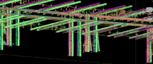
Arek Surveying is a professional land surveying company that is proud to offer a wide range of services to its clients, including 3D scanning with state-of-the-art Trimble equipment. This cutting-edge technology allows for precise data collection and analysis, which gives clients the ability to make informed decisions about their upcoming projects. With Arek Surveying P.C.'s 3D scanning services, clients can get a detailed look at their projects in a way that was never before possible. The Trimble equipment used by us is designed to capture high-resolution images, precise measurements, and accurate data. In the end, we are able to provide clients with a comprehensive view of their surroundings. Ultimately allowing them to make more informed decisions about their projects.
Contact Arek Surveying
Arek Surveying P.C. is dedicated to providing the highest level of service to its clients, and its 3D scanning services are no exception. The company's team of experienced professionals work closely with clients to ensure that their needs are met and exceeded, and that they are completely satisfied with the results. For more information about our surveying services, please reach out to us today. We will gladly answer any questions or concerns you may have regarding these services. From regular property surveys to large construction projects in New York and New Jersey, the surveying team at Arek are the perfect team for any surveying job.
Trimble Scanning Features

At Arek Surveying, we utilize the best in 3D scanning for our surveying services. This means we use Trimble, a company focused on making the day-to-day job of surveying and scanning faster, easier and more productive. The features, functions and software components of a Trimble, aided by Autodesk Civil 3D drafting software, are designed to boost efficiency in the field and in the office, all without compromising performance and accuracy.
Trimble solutions empower quick and accurate scanning, registration and creation of comprehensive deliverables. Here are the areas we can use this equipment for:
- Surveys, such as topographic, corridor and volumetric.
- Civil infrastructure, such as roads, highways, bridges, dams and tunnels.
- Urban environments, such as parks, buildings, and streets.
- Industrial environments, such as plants, ships, factories, and tunneling.
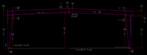
- New construction developments, such as completed floors as-builds, erected steel location, desired features as-builds.
There are other applications as well for this equipment. Due to our years of experience, the surveyors at Arek Surveying can expertly use Trimble 3D scanning technology during our surveying services. Meaning that you get the best results possible, all within your budget. With Trimble, they pride themselves on scanning for everyone and their advanced 3D scanning systems let us scan with confidence and produce results for our services you can trust.
Why We Use Trimble for 3D Scanning Services
At the core of Trimble’s 3D laser scanning portfolio is exceptional technology. This great technology provides superior accuracy and range for basic to challenging scanning environments. Trimble’s advanced software and scanning solutions gives us the power to quickly capture, analyze, model, and deliver the following for our clients:
- Easier, more streamlined workflows.
- Unmatched productivity in both the field and office.
- Reliable services in demanding environments.
- High quality, low noise data to reduce processing time.
- Nice versatility supporting a wide range of applications.
- Powerful software producing dynamic deliverables.
3D Scanning Services Benefits
Here are some of the more notable benefits of utilizing 3D scanning services.
- High Accuracy: Ability to capture precise measurements, while also reducing errors.
- Cost-Effective: Reduce costs overall by limiting on-site work.
- Limit Mistakes: Limit your potential mistakes due to incomplete measurements and photography.
- Improved Record Keeping: Obtain a complete and precise record of existing conditions.
- Efficient Data Collection: Quickly gather comprehensive data of existing structures.
- Enhanced Planning: Provide detailed models for better architectural design and renovation planning.
- Improved Facility Management: Facilitate efficient maintenance and management of building facilities.
- Virtual Job Sites: Seamlessly provide remote access to accurate building data, which enhances collaboration and decision-making.
- Enhanced Safety: A safer way to complete surveys in general.
- One For the Record Books: Get a permanent photo record for immediate or future use.
Avoid Problems by Using 3D Laser Scanning
Here are some great problems you can avoid when using 3D laser scanning.
- Protects from liability.
- Nothing is built to plan, which means documentation is often dated.
- You have accurate information at the start of the design process.
- As-built drawing updates get the least effort.
- No method comes close in performance for capturing as-builts.
- Overall, eliminates risks and rework.
- Project communication is clearer.
- Reduces uncertainty with schedule and cost.
- In the end, it creates a permanent, shared record.
More About 3D Scanning Surveying Services